
I originally wrote this for my non-geomorphologist colleagues at work, but I think it’s of interest to a wider audience so I’m posting it here too. It’s not very slick and some of the explanations of form and process are a bit…simplified, but it will do. I’d actually quite like to discuss it if you have any thoughts/questions.
The fluvial geomorphology of East Anglia: a history lesson
East Anglia is geomorphologically fascinating owing to its glacial and peri-glacial history, and spatially variable geology. As recently as 18 thousand years ago, the British and Irish Ice Sheet would have covered large areas of north Norfolk; Essex and particularly Suffolk would have been peri-glacial (very, very cold but not subject to glacial processes). Following the retreat of the ice sheet, East Anglia would have experienced glacial outwash flows – high energy cascades of water, transporting sediment far heavier than can be carried by our rivers now. This is where all the gravel in the area comes from.

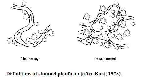
Channels would have evolved, starting off as highly dynamic sediment-laden braided systems. Thereafter, vegetation and a loss of energy (as the glaciers stopped melting) would have restricted channels to an anastomosed state. Over chalk geology, a high base-flow index would have limited the energy available for geomorphic work and after around 5 thousands years before present, the single-thread planform of these rivers is unlikely to have significantly changed (unless due to large woody debris [LWD] – more on that later in this post). Over boulder clay, river systems would be flashy, with overbank flows resulting in lateral accretion (fine sediment being deposited on the floodplain), and, combined with a forested landscape, creating an anastomosed (multi-threaded) channel network. This is important when we think about river restoration and notions of ‘naturalness’. How can we restore a river to its natural state when there is no longer active gravel transport or supply? Is it right to install riffles in systems that, naturally, would be dominated by fine, cohesive sediments? A topic for another post, I suspect!
 In these low-energy rivers, riparian vegetation would have played a major role in the development of fluvial systems. However, it’s a bit more complicated than wood falling in and hoping for the best. Different wood structures would have created different landforms. For example, a partially submerged bridging piece of LWD could divert flow downwards and lead to the creation of a scour pool. A non-bridging submerged piece facing up-stream could divert flow towards the bank and cause bank erosion. A non-bridging submerged piece facing down-stream could divert flow away from the bank and lead to the creation of a silt berm. These are the mechanisms by which our river systems would naturally change, and there is some merit in arguing they are the mechanisms we should employ when restoring our streams.
Modern-day problems – tackling sediment sources
Being the arable agriculture heartland that it is, East Anglia produces a lot of fine sediment run-off from fields, causeways and roads. Beyond siltation, issues of nutrient loading due to organic sediment inputs from fertilizers and slurry are a concern.
The solution is not periodic maintenance of river systems (e.g. dredging or weed cutting) but the cessation or mitigation of sediment inputs. In combination with appropriate in-channel modifications, excessive fine sediment inputs can be negated (e.g. combining river restoration works with the plantation of a riparian buffer strip). Half of the battle is returning rivers to a position where they can regulate themselves and the other half is moderating our inputs of fine sediment.

Reblogged this on Tales from the Essex riverbank and commented:
When we are trying to improve our rivers, it is important to know how we got to where we are today. This is a great post from Trev Bond, our geomorphologist based in Ipswich, helping us to get to grips with the issues.