Regular readers of the blog will remember a few years ago I blogged about some of my PhD research on trying to assess how changing volumes of wood in rivers affects the likelihood and magnitude of flooding. At the time I felt the work was stuck in a metaphorical publishing logjam and thought it would be a while, if ever, before it got published in a journal. In a wonderful piece of serendipity a colleague who was editing a special edition of the journal Earth Surface Processes and Landforms read the blog and thought the work would be a good fit and so invited me to submit it. The paper was recently peer reviewed and accepted for publication. I mention this as an anecdote to counter what academics are sometimes told about blogging damaging chances of publication, or being a waste of time. Following the work being through the rigours of peer review I thought it was a good time to revisit it and reblog the major findings* now it’s all scientifically official!
The background to this work is that we know if wood is put into a river then flood water moves slower through/around it, and thus for a short distance downstream flood water will have a longer “travel time”. What no-one has done before is look at the effects upon flooding at a distant downstream location (such as a town) of changing the speed water moves through a small sections of the river catchment upstream of it. What we were interested in, and what the EA provided funding to look at, is how changing land use and/or changing in-stream wood quantities (particularly in the context of river restoration) could change downstream flood behaviour. This idea of natural flood risk management is a really hot topic recently covered on Countryfile, The One Show, The Today Programme and many more.
To investigate land use and flooding we used a computer model called OVERFLOW which was also used for the experimental “soft engineering” flood defence project at Pickering, N.Yorkshire which has received a lot of attention since this winter’s floods. This model allowed us to run thousands of model variations to look at the effects of changing wood in rivers and changing afforestation at a wide range of scales, but also different spatial arrangements within a catchment. In order to set up and calibrate the model we used data on topography, land use, rainfall and river levels for a catchment within the New Forest National Park – the Lymington River. We were principally concerned with the depth of water near the town of Brockenhurst.
The key points that emerged from the modelling study are:
- Adding artificial logjams to stretches of river as short as 500m can change the height of a flood peak in a downstream town, but these changes are very small and have highly variable magnitude and directionality.
To unpack this point a little more – putting logjams into a river in some locations can increase the depth of flooding downstream.
- Broadly speaking steep headwater reaches with wood in them had little to no effect on downstream flooding – in very simple terms this can be put down to the water flowing in steep streams moving faster and having more energy, and thus being less susceptible to being significantly slowed by additional wood. I found streams with a slope of >0.005m/m or greater showed little change in flood peak upon adding wood.
- In middle to lower parts of the catchment changes in flood height at the town are observed, but there is little predictability in response. I.E. with my data I am unable to predict whether putting wood into a river channel around 3-15km upstream of a town will decrease or increase flood risk.
- Generally as the length of river with wood in it increases, the magnitude of change in the flood peak height also increases – i.e. wood in more river channels results in bigger changes to flooding. However the direction of this change remains highly variable.
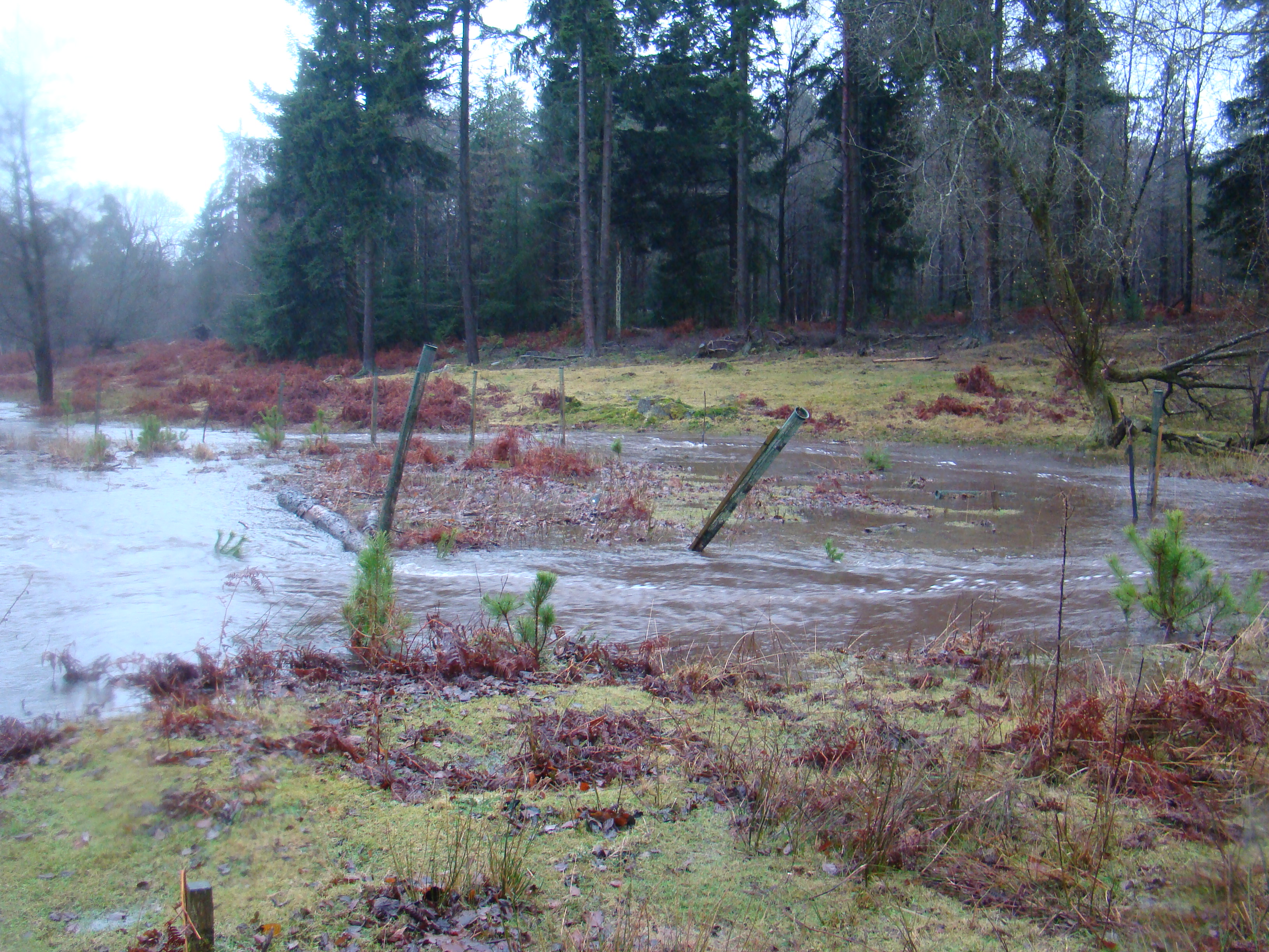
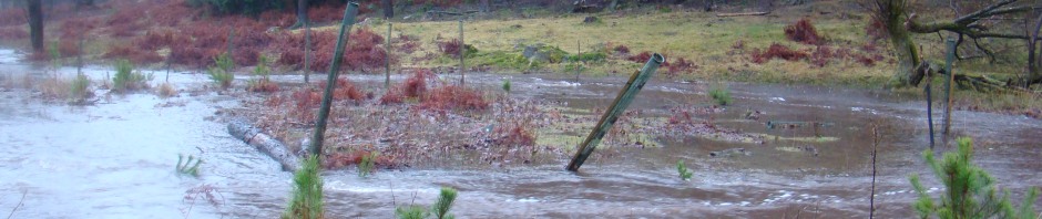
Meander bend during flood, looking downstream. River channel flows from left to right, before curving back towards top left. Water is flowing rapidly over the floodplain on the left, bypassing the bend in the river.
The overall conclusion is that just inserting wood and/or logjams into rivers within a catchment as part of flood control for a downstream location is highly unpredictable. The reason for this is that locally logjams force water out onto the floodplain, if this floodplain is grass or scrub then the flood water is capable of still moving fairly rapidly across it, indeed in some cases it can flow directly down-valley and bypass bends in the river.
The real benefits in “rewilding” for flood control comes from restoring floodplain forests. Complex forested floodplains dramatically slows water moving over them as they have an irregular surface covered by tree roots, upright tree trunks and dead wood. Our model runs for scenarios where wood is inserted into the river and a forest is allowed to grow on the floodplain show substantial and predictable responses in downstream flood height.
- Restoring floodplain forests to short sections of river of 1-2km can reduce downstream flood height by 1% after 25 years growth.
- There is predictable pattern of response with floodplain forest in lower parts of a catchment (e.g. near a town), increasing flood height. However when used in the middle and upper reaches of a catchment a reduction in flood height is modelled.
- As the extent of restoration increases the magnitude of change in downstream flood peak increases and displays a similar spatial pattern (near the town increases flood height, further upstream reduces flood height)
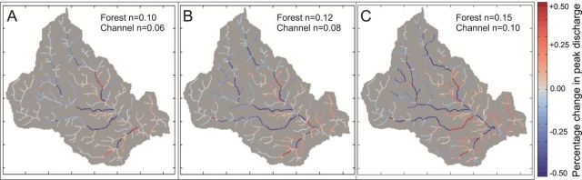
This Figure from the paper shows the spatial pattern of flood response to very small areas of afforestation (A=~25yr, B=~50yr, C=~100yr). Note how upper parts of the catchment are neutral or blue (reduce flood risk) and areas close to the outflow (bottom right) are red (increase flood risk), and how this pattern gets stronger as the forest ages (A-B-C).

A map showing an example of a sub-catchment area. This one is 14.6% of the total area and if forested is predicted to lead to a 5.3% reduction in flood peak height at the downstream urban location after 25 years growth
The most promising scenarios, and the real take home message is the restoration of floodplain forests to entire “sub-catchments” of the main catchment (a tributary of the main river and all streams draining to it) always decreases flood peak height after 25 years growth, and can have dramatic effects. If this is done for areas of 20-35% of the catchment reduction in flood peak height of 10-15% are modelled after 25 years of forest growth.
As a simple analogy during a flood many “packets” of water are delivered to the main trunk river from all its tributaries. If the delivery of a single large “packet” of water can be significantly delayed it will then arrive at the main river after the peak of the flood, and thus the main flood peak height has less “packets”of water in it and is lower. Imagine it as a tapas meal where you’ve ordered too many dishes, your table is full already, but thankfully the waiter brings your albondigas after the gambas pil-pil are finished and thus your table doesn’t overflow with tapas.
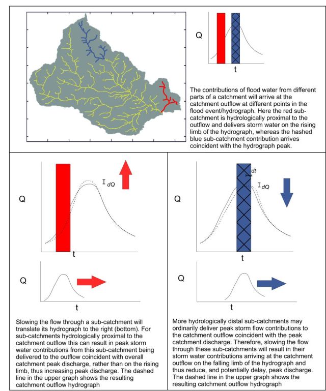
This conceptual model from the paper illustrates the concept of “sub-catchment desynchronisation”, and explains how slowing the flow in one place can make flooding worse elsewhere.
The two most important implications for flood control using river restoration or re-wilding are:
- Applying wood and/or logjams on their own to short stretches of river of 1-5km has a highly variable effect on flood peak height at a downstream urban location of ±4%. The (well known) local flood wave attenuation effects of logjams do not always translated to reduced downstream flood risk. Given the difficulty in predicting the response before installation this is a highly risky approach and should probably be avoided unless there is extensive site experience/local knowledge/investigation beforehand.
- The most promising (and practical) scenarios are to restore small headwater sub-catchments representing 10-15% of the total catchment area, where reductions of 5-6% in flood peak height can be seen after 25 years, with this reduction increasing to 7-8% after 50 years growth. If the area is increased to a large sub-catchment representing 25-35% of the catchment area reductions of 10-15% in flood peak magnitude can be seen after 25 years (with again bigger reductions as the forest ages and matures); although restoration of such large areas may prove impractical.
It is important to note that this modelling only looks at the speed of water moving through the river network and off hillslopes, it does not take any account of the reductions predicted in the amount of water reaching rivers through trees increasing infiltration rates of rain/runoff into soils, as George Monbiot has talked about extensively. So we could expect to see even greater reductions in flood peak discharge downstream than predicted just from flood wave travel time modelling.
In conclusion although governmental and public interest in the concept of “rewilding” rivers for flood control is promising, it is important to recognise that the local effects of wood in rivers slowing flow can have surprising and counter-intuitive effects when looked at in the context of a whole river catchment. We need to do a lot more work in this area and in the meantime the insertion of logjams and dead wood into rivers for flood control should be used with caution and extensive site analysis. Scientifically the case is getting much stronger for targeted afforestation of uplands as a part of natural flood risk management.
*- elements of this post have been copied from the early blogpost linked to above.

Simon. Just out of interest, did you model tree planting in the upper to mid catchment and then additionally model the effect of adding in forestation of the lower catchment? Interested to know whether it could add to the positive effect in any way, or still have a negative effect. Is it possible to find roughly how far (in % terms) up the catchment the ‘cut off’ point occurs, or is that wholly dependent on catchment characteristics?
Hi Mike
I think it’s really going to be dependent on catchment characteristics. One of the types of scenarios we didn’t do was looking at large blocks of woodland positioned only somewhere in the lower catchment as targeted planting. We did look at isolated blocks of woodland of ~2-3km^2 positioned all around the catchment, as well as blocks of ~10-15km^2 and these didn’t tend to have a huge impact one way or another, certainly when compared to the planting from the catchment source/boundary downwards.
Effectively the way I interpret it is that planting an isolated block of woodland acts like a “speedbump” on one particularly tributary or branch of the network, and although this might have a big local effect, in the context of a whole catchment that relatively short section of slowed water may not have a big impact. Whereas if its possible to slow the passage of rain within a whole sub-catchment area from the point it hits the ground to the point it “exits” the sub-catchment and joins a wider part of the channel network it’s going to have a greater potential to be decoupled from the main flood wave.
Because of the nature of the modelling approach we used it’s better to talk in terms of probabilities and patterns, rather than exact numbers (which is why all of our results are presented as % change), so I’d be reluctant to put a firm number on where the change from +ve to -ve change to flood risk occurs in respect of small scale forest planting. The outflow of the catchment (in the model) is a 5th order channel (based on how we calculated headwaters) and broadly speaking it seems as though subcatchments flowing into the main channel when it is 3rd order are positive to reduce flood risk, the shift occurs in our catchment somewhere in the 3rd-4th order main channel (i.e. smaller sub-catchments flowing into the 4th order channel are variable in effect).
The place at which this happens for any given catchment is really going to depend heavily on individual catchment characteristics though. It’s also important to say that we’re just talking about general patterns and biggest effects. It IS possible that in a specific catchment a block of woodland in the lower catchment might have some positive, measurable effect at reducing flood risk – we’re certainly not ruling it out, just saying the work suggests its less likely.
Simon
Thanks Simon. Now we’ve had the theory, wouldn’t it be nice for those agencies with the necessary clout to crack on and make it happen in practise. After all, it’s going to take decades to take effect and if it doesn’t work well, we could always chop them down again for firewood. Or is that too practical!
I think there is something to this. Eventually we (as a society) have to take a leap of faith based on the best science available and just do it, or decide afforestation for flood management is not for us. In the end it’s just not practical to set up full scale natural studies and wait 50-75 years for conclusive results and then (if it works) wait another 50-75 years for the subsequently approved roll out of more forests to grow!
There is also the joke – “What if we’re wrong and we create acres of beautiful mature woodland for nothing?”!!
Pingback: Can we justify preserving landscapes for heritage? | The River Management Blog
Wouldn’t that be just dreadful 🙂 Have you, and other readers got wind of the EFRA committee review into flooding. Plenty of scope for plugging NFM, tree planting, upstream storage, sensible land management etc if you look at the terms of reference here: http://www.parliament.uk/business/committees/committees-a-z/commons-select/environment-food-and-rural-affairs-committee/news-parliament-2015/future-flood-prevention-launch-15-16/
Dear Dr. Simon Dixon,
I was delighted to read about your research on the effect of large scale tree planting on reducing the flood effects downstream. While we all talk about the benefits of trees, little work had been done before to prove this in such scale.
As you can see in my website (http://ky59.blogspot.com) I have been promoting such ideas, mainly using ancestral technologies, as an alternative to typical ‘engineered solutions’ to flooding. I would like to use your research results in my new book on “Ancient water nurturing practices” (the spanish version was written in 2012) for the benefit of practising technicians.
Unfortunately, I am an independent researcher in Ecuador and my minuscule budget does not allow me to buy your article at Wiley web site. Besides, I would like to add detailed information about your research in my book so that people from other geographical locations can experiment on their own and learn what produces the best results.
Thus, I appreciate if you would share with me a digital version of your final report on that research work. I try to disseminate my work free or at a minimal cost, so that the public from developing countries can access them and of course, acknowledge every help I get from other researchers. Thank you in anticipation of your help,