
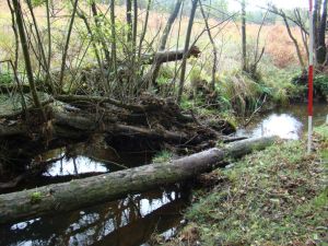
Logjam in the New Forest
I was excited this week to have a paper accepted in the journal Ecohydrology, not least as I think the findings could prove to be really useful for river restoration and river management. In this post I want to try and break down the implications of the research for river management/restoration practise. At a later date I’ll break down some of the science implications in another post.
At its simplest the paper is trying to link together the geometric form and architecture of a logjam and the changes in local erosion and deposition associated with it. There is a wealth of information in the academic literature on the effects of logjams at promoting particular features/habitats, such as a greater number of logjams in a river being related to a greater number of pools. Many river managers and river restoration professionals will probably know how to install a “tree kicker” to promote the scouring of fine sediment and creation of exposed gravels, by using an angled piece of wood to concentrate ambient flow and promote local scour.
However, perhaps surprisingly, there isn’t much in the literature (academic or professional) linking what a logjam looks like and what it does in terms of geomorphology. This makes it very hard for professionals to design engineered logjams to accomplish a particular management objective. One of the key objectives I had was to try and understand if there was a link between, for example, bigger logjams and a higher likelihood of a pool forming, or logjams against one bank and scour.
Without going into too much detail about the method the main principle is to collect measurements of the logjam itself and the geomorphological change to the channel around it, along with measurements of the channel dimensions. All the measurements are then converted to ratios, for example by dividing logjam width by channel width, making it much easier to compare between sites. I end up with 7 variables, and do a cluster analysis on these so that all the logjams in my river “clump together” statistically into groups. This reveals the biggest groups, or types of logjam in a river and also what the architecture and geomorphological effects of these logjam groups are.
We can display these logjam clusters as radar plots (fans of console games will notice this is similar to how sports games display player stats!), which allows us to compare visually the different types.
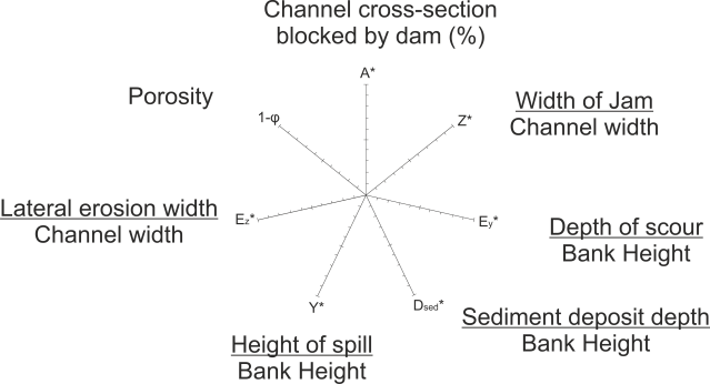
Basic radar plot showing the seven variables and how these are calculated from field measurements
One of the key findings of the paper is the link between the relative sizes of the logjam (compared to channel cross section) along with its porosity (the amount of void space in the structure) and the association with erosional or depositional features. A low porosity is key as it increases hydraulic resistance and backs up water behind the logjam (rather than allowing it to flow through the structure), this then either spills over the top, scours underneath or is diverted towards a bank. It’s this concentration of flow, with an associated increase in velocity, that leads to focused erosion and the creation of pools/bank erosion.

The main logjam clusters from the study river. Note that the upper 3 arms [ A* (cross section filled), Z* (logjam width/channel width) and 1-phi (porosity)] describe the main architecture, the four lower arms of the radar describe the effects on geomorphology & hydraulics. (from Dixon, 2015 fig. 2)
The importance of porosity is also seen for smaller logjams, where I found two distinct types of logjams which partially fill the channel; those with loose structures which do very little geomorphologically, and those with moderate to low porosity which divert flow and cause moderate bed scour.
So the overall message would be; if a manager can afford to be relaxed about exactly what geomorphological change is occurring within a given reach, then tight logjam structures with low porosity (both channel spanning and partial) appear to be the best way to increase general geomorphological hetrogenity (pools, berms, scour, lateral migration) and thus habitat provision.
There are lots of caveats here, the most important being these are statistical results from just one river. If engineered logjams were designed based on these results in a similar river, and if there were a hundred of them, the overall patterns should hold true. However it is very hard to predict the effects of a single logjam based on its structure (yet). The plan is to conduct more research in other rivers using this method (and hopefully other researchers will also adopt it and we can combine our results), this will allow us to really firm up some guidance for building engineered logjams to achieve specific goals.
The paper will be put into my University’s archive as open access soon and I’ll update this post with a link once that happens.
