

UPDATE: This work was accepted for publication in the journal “Earth Surfaces Process & Landforms” on 12/02/2016. http://onlinelibrary.wiley.com/doi/10.1002/esp.3919/abstract
One of the key objectives of my PhD research at University of Southampton was to try and assess how changing volumes of wood in rivers affects the likelihood and magnitude of flooding. The amount of wood in rivers can increase for various reasons, such as artificial insertion in the river for river restoration, river managers choosing to cease clearing natural deadwood from channels, or the growth/restoration of streamside (riparian) forests. We know that if wood is put into a river then flood water moves slower through/around it, and thus for a short distance downstream flood water will have a longer “travel time”. What no-one has done before is look at the effects upon flooding at a distant downstream location (such as a town) of changing the speed water moves through a small sections of the river catchment upstream of it.
My research in this area was sponsored by the Environment Agency in the UK. Currently my thesis is awaiting examination, and for various reasons the publication of a key set of results in the academic literature is not likely to appear until the later part of this year at the earliest. Given the current interest the subject with articles in The Guardian and BBC in the past few days I thought it timely to write a short blog post giving a précis of the main findings of a computer modelling study I conducted on the effects of adding wood to rivers as a flood control method.
I used a computer model (OVERFLOW written by Dr Nick Odoni) also used for the experimental “soft engineering” flood defence project at Pickering, N.Yorkshire mentioned in Roger Harrabin’s article for the BBC. This model allowed me to run thousands of model variations to look at the effects of changing wood in rivers at a wide range of scales, but also different spatial arrangements within a catchment. What I am interested in is the effect upon flooding at a downstream urban location when wood is inserted into rivers through the catchment in various arrangements.
I am concious I need to restrain myself as I could (literally and demonstrably) write over 70 thousand words on this subject!
The catchment I modelled is within the New Forest National Park and has fairly low slopes, it is around 100km² and contains around 100km of stream length. The outflow from the catchment is the Lymington River at the town of Brockenhurst.
The key points that emerged from the modelling study are:
- Adding artificial logjams to stretches of river as short as 500m can change the height of a flood peak in a downstream town, but these changes are very small and have highly variable magnitude and directionality.
To unpack this point a little more – putting logjams into a river in some locations can increase the depth of flooding downstream.
- Broadly speaking steep headwater reaches with wood in them had little to no effect on downstream flooding – in very simple terms this can be put down to the water flowing in steep streams moving faster and having more energy, and thus being less susceptible to being significantly slowed by additional wood. I found streams with a slope of >0.005m/m or greater showed little change in flood peak upon adding wood.
- In middle to lower parts of the catchment changes in flood height at the town are observed, but there is little predictability in response. I.E. with my data I am unable to predict whether putting wood into a river channel around 3-15km upstream of a town will decrease or increase flood risk.
- Generally as the length of river with wood in it increases, the magnitude of change in the flood peak height also increases – i.e. wood in more river channels results in bigger changes to flooding. However the direction of this change remains highly variable.
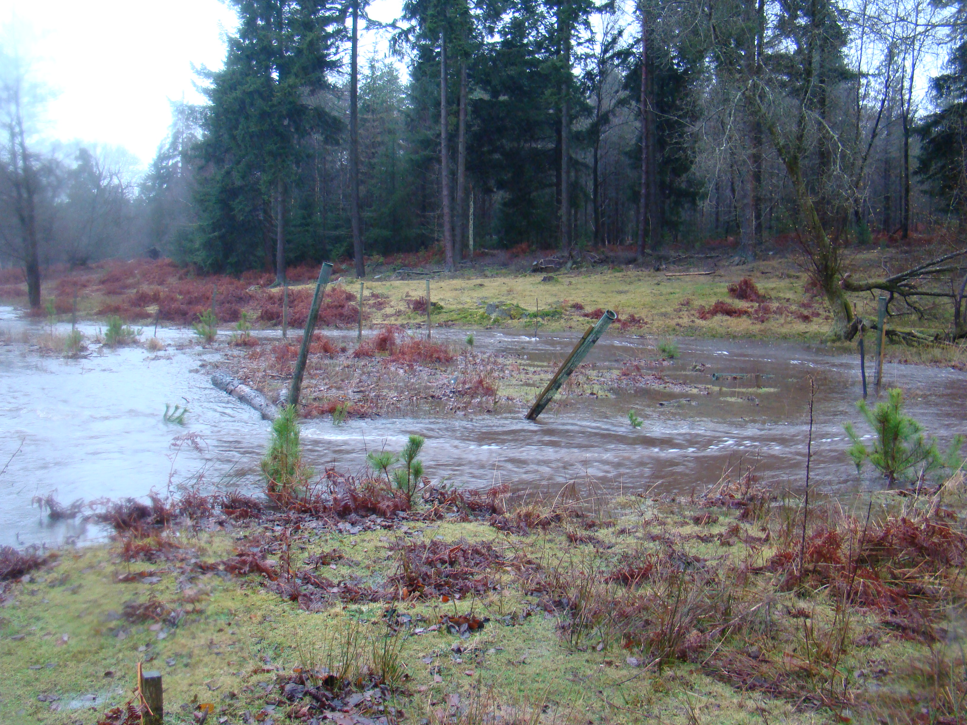
Meander bend during flood, looking downstream. River channel flows from left to right, before curving back towards top left. Water is flowing rapidly over the floodplain on the left, bypassing the bend in the river.
The overall conclusion is that just inserting wood and/or logjams into rivers within a catchment as part of flood control for a downstream location is highly unpredictable. The reason for this is that locally logjams force water out onto the floodplain, if this floodplain is grass or scrub then the flood water is capable of still moving fairly rapidly across it, indeed in some cases it can flow directly down-valley and bypass bends in the river.
The real benefits in “rewilding” for flood control comes from restoring floodplain forests. Complex forested floodplains dramatically slows water moving over them as they have an irregular surface covered by tree roots, upright tree trunks and dead wood. My model runs for scenarios where wood is inserted into the river and a forest is allowed to grow on the floodplain show substantial and predictable responses in downstream flood height.
- Restoring floodplain forests to short sections of river of 1-2km can reduce downstream flood height by 1% after 25 years growth.
- There is predictable pattern of response with floodplain forest in lower parts of a catchment (e.g. near a town), increasing flood height. However when used in the middle and upper reaches of a catchment a reduction in flood height is modelled.
- As the extent of restoration increases the magnitude of change in downstream flood peak increases and displays a similar spatial pattern (near the town increases flood height, further upstream reduces flood height)

A map showing an example of a sub-catchment area. This one is 14.6% of the total area and if forested is predicted to lead to a 5.3% reduction in flood peak height at the downstream urban location after 25 years growth
The most promising scenarios, and the real take home message is the restoration of floodplain forests to entire “sub-catchments” of the main catchment (a tributary of the main river and all streams draining to it) always decreases flood peak height after 25 years growth, and can have dramatic effects. If this is done for areas of 20-35% of the catchment reduction in flood peak height of 10-15% are modelled after 25 years of forest growth.

Flow out of a sub-catchment/tributary is slowed, this translates the hydrograph for that sub-catchment to the right (see upper right of figure) i.e. moves it later in time. The water flowing out of this subcatchment would normally arrive at the town downstream during the green part of the main hydrograph (the flood peak). By moving later in time it arrives after the peak – the new hydrograph is shown by the dotted line, which is lower, later and lasts for a slightly longer time. Figure from Dixon, 2014
As a simple analogy during a flood many “packets” of water are delivered to the main trunk river from all its tributaries. If the delivery of a single large “packet” of water can be significantly delayed it will then arrive at the main river after the peak of the flood, and thus the main flood peak height has less “packets”of water in it and is lower. Imagine it as a tapas meal where you’ve ordered too many dishes, your table is full already, but thankfully the waiter brings your albondigas after the gambas pil-pil are finished and thus your table doesn’t overflow with tapas.
The two most important implications for flood control using river restoration or re-wilding are:
- Applying wood and/or logjams on their own to short stretches of river of 1-5km has a highly variable effect on flood peak height at a downstream urban location of ±4%. The (well known) local flood wave attenuation effects of logjams do not always translated to reduced downstream flood risk. Given the difficulty in predicting the response before installation this is a highly risky approach and should probably be avoided unless there is extensive site experience/local knowledge/investigation beforehand.
- The most promising (and practical) scenarios are to restore small headwater sub-catchments representing 10-15% of the total catchment area, where reductions of 5-6% in flood peak height can be seen after 25 years, with this reduction increasing to 7-8% after 50 years growth. If the area is increased to a large sub-catchment representing 25-35% of the catchment area reductions of 10-15% in flood peak magnitude can be seen after 25 years (with again bigger reductions as the forest ages and matures); although restoration of such large areas may prove impractical.
It is important to note that this modelling only looks at the speed of water moving through the river network and off hillslopes, it does not take any account of the reductions predicted in the amount of water reaching rivers through trees increase infiltration rates of rain/runoff into soils, as mentioned by George Monbiot last week. So we could expect to see even greater reductions in flood peak discharge downstream than predicted just from flood wave travel time modelling.
In conclusion although governmental and public interest in the concept of “rewilding” rivers for flood control is promising, it is important to recognise that the local effects of wood in rivers slowing flow can have surprising and counter-intuitive effects when looked at in the context of a whole river catchment. We need to do a lot more work in this area and in the meantime the insertion of logjams and dead wood into rivers for flood control should be used with caution and extensive site analysis.

Reblogged this on Tales from the Essex riverbank and commented:
Matt says: Another fantastic blog post from Simon Dixon. We are getting to grips with how to play tunes on the flow to reduce downstream peaks, and this is fundamental to blending cost-effective flood risk management with good ecology.
Neat results, and information that I think is applicable to stream restoration and management in the US as well. Did you evaluate the effects of varying widths of floodplain forest? In the US, there are varying rules about the width of the riparian buffer that must be protected, and I wonder if there is any basis in flood reduction for advocating for a particular width. I look forward to seeing this in the academic literature.
Anne, no I didn’t do anything on varying the width, just focused on the spatial patterns. I have done some simpler modelling in a steep catchment using Lisflood-FP before and interestingly that showed little difference between a buffer strip filling the 1-in-100yr flood envelope and forests filling the whole valley. Take with pinch of salt though. Perhaps slightly surprisingly that same set of modelling also showed sequential cross-valley buffers more effective at attenuation than same area of forest as a thin lateral buffer boardering stream.
I hope it will one day make it into the academic literature, but unfortunately the team who developed the model I used have yet to get round to finishing/publishing the paper introducing the model. So my work is at a frustrating publishing bottleneck at the moment waiting for that to happen.
Simon,
Great work and sorry to hear publishing is at a bottleneck. If there is any chance of keeping me in the loop when it does get published I would certainly like to share the full paper with my coleges (sp). Thanks for all your hard work.
Lisa
Lisa
Yes happy to do that (the more people who read it the better!). You can either keep an eye on the blog and/or twitter. Alternatively you can post your contact details here and I will make a note of them and just not approve the comment, then delete it. Therefore your email won’t be published on the web. Finally you could google me and university of birmingham and it should bring up my staff page/email. Plenty of options!
I guess the inevitable issue that arises is that the majority of farmers’ most valued in-bye land is in the valley bottoms, in exactly the location where the best flood attenuation effects of forest are experienced. Instantly the challenge becomes political.
Thanks for the comment Hugh; you’ve cut right to the heart of it. Science is one thing, but actually putting this stuff into practice may be unlikely in most cases. Politically I think my message is fairly unpalatable in the current climate (forgive the pun), as I’m not reporting great results for the small scale river works that are currently popular with landowners/policy makers such as putting in some logjams, or even great results for little areas of buffer strips, but instead saying if we really want demonstrable flood protection from land use/rewilding we’re going to have to set aside areas of ten square kilometers or more and afforest them. Inevitably in most cases the current owners of that land are unlikely to experience the worst (or perhaps any) ill effects from flooding downstream, so there is no imperative to do it from the point of view of self-interest.
In an egalitarian or utopian society just planting a lot of forests and leaving them alone could be a fantastically cheap option, in reality I think there would need to be grants, subsidies, etc, etc to land owners and it may stack up to be a very expensive option for that reason.
Answering the science question may turn out to be infinitely more simple than answering the ensuing political question!
Great article & site – really looking forward to reading more on here!
You mention in the comment above the need for quite significant land use change in order to have measurable effects. I guess you’re familiar with Nisbet & Thomas’ work – http://onlinelibrary.wiley.com/doi/10.1111/j.1747-6593.2006.00056.x/abstract which suggested that relatively minor schemes (less than 2% of the catchment in their example) could have a significant impact on attenuating peak flow. Just wondered where the difference of opinion comes from?
You also mentioned the political/implementation challenge – given the current vogue for market-based solutions, is there any interest in your findings from the insurance industry?
Cheers,
Ian
Ian
I am very familiar with Nisbet & Thomas’ work. I can see how on the face of it there appear to be different conclusions, but in fact I think my results broadly mirror theirs, the difference is that I’m looking at a slightly larger catchment scale and thus there are some confounding interactions between different sub-catchments/tributaries. I also found that less than 5% of the catchment restored can have large effects on attenuating peak flow (although only for peak height not for delaying time of peak as I believe they did), however where my results differ is that I didn’t find that reduction for all (or even most) model scenarios of small scale restoration, particularly with logjams.
For <2% restored with logjams I saw reductions of peak height up to 3.5%, however there were also increases of up to 4%. The vast majority (>80%) of scenarios at that scale however showed +/-1% changes (which is getting down towards margins of model uncertainty as well). So I’m very comfortable with Nisbet & Thomas’ conclusions that <2% restoration can dramatically reduce flood peaks, where my results expand upon this is to suggest such a response is not universal at the catchment scale.
My overall recommendations for logjam use is therefore that more detailed modelling (such as that used by Nisbet & Thomas) is used to carefully plan exactly where logjams are places to ensure that the desired effect is obtained. Its is most definitely NOT the case that putting logjams anywhere in the catchment will lead to peak reductions.
As yet there is no interest from industry in the findings, I suspect that the nature of land ownership in the UK (alluded to in the main article) will mean that the owners of land where restoration could be effective are not necessarily the same as the owners of land/properties which are at risk of flooding and/or seeking insurance. This maybe more relevant where bodies such as the National Trust or Forestry Commission own/manage large areas of land, but I’m not sure.
Pingback: Pacific Piano Performance Posts | Planting trees ‘could stop flooding’
Pingback: Planting trees ‘could stop flooding’ | NewzUpdate.US
Pingback: Planting trees ‘could stop flooding’ | newzupdate.info
Pingback: D Richard Dance Blog » Blog Archive » Planting trees ‘could stop flooding’
Pingback: Planting trees ‘could stop flooding’ : One Caribbean Radio | The Global Mix
Pingback: Blog David Singui » Planting trees ‘could stop flooding’
Hello Simon! This is GREAT work, I must say; I’m very impressed. A few things to consider, though:
– contact *Tom Nisbet* and Huw Thomas at Forest Research, who know a lot about this also, and who were, along with *Stuart Lane* at Durham (now at Lausanne), pivotal in getting the ‘Slowing the Flow at Pickering …’ project put together;
– although “OVERFLOW” is my model and does a reasonable job, and I have a better build for it in mind (when I can make the time!), it is important to realise that where possible, the results should be tested using a more physically based hydraulic model, such as ISIS, TUFLOW or similar. I know this is VERY difficult to do – for a start, you need input hydrographs at every channel head! – and a major challenge for scientists and indeed the whole hydraulic engineering community interested in flooding, but that is the direction we need to go, I think;
– bear in mind that for Pickering and Sinnington, we also used ‘minibunds’ i.e. large woody debris structures that extend across the flood plain. In the Sinnington (R. Seven) case, we are talking about the smaller, local floodplain type areas nearer the channel heads or along the lower order streams. I suspect that these minibunds are very effective and could well be applied – with care – to your system and other systems. Otherswise, what you can find is that the LWD dam in the stream forces the water out of bank, and it flows straight back in again just down stream of the structure, and much of the attenuation effect is lost. The minibunds are, however, v. difficult to model (“OVERFLOW” can’t manage them quite yet, but I think my adapted bunding model will work instead, using Muskingum routing or similar to predict the hydrographs). The locals (Pickering and Sinnington) do think these structures are having a beneficial effect, though, which is something; BUT *we now need the gauging data and hard numbers*;
– also pse bear in mind that these interventions are not maintenance free, nor are the geomorphically neutral. There may yet be problems with scour or deposition, for example, particularly after big events, and this needs to be monitored carefully. Likewise, we must watch our for the effects of vandalism, rot or collapse of the timbers, and so on, all of which could be seriously detrimental.
Anyways, well done, v. good post!
Best wishes,
Nick (Odoni),
Good to hear from you Nick, I’ll try and drop you an email later on.
You are quite right about the need to model with more physically based models where quantitative predictions are needed, or in advance of installing any sort of catchment interventions such as the one discussed/implemented in Pickering. The variability in flood response to installation of logjams in my results mentioned above I think only further emphasises this need.
I think the big contribution the OVERFLOW modelling approach has been able to make in this study is the ability to run thousands of alternate scenarios as a heuristic, rather than a predictive modelling exercise and demonstrate the importance of sub-catchment timings in respect to flood control (something our mutual friend Ian Pattison has also previously shown). In that respect being able to show how predictable the response of “rewilding” (allowing growth of floodplain forest) in headwater sub-catchments to reducing flood peak height is the key message here.
Hi Simon,
Nice to see you get some publicity for this type of work, and the New Forest projects, with a well-timed blog ( I came across it via a link in a BBC article). If you do want to go down the route of using a more physically based model then I might be able to help as I work for a software house who produce the kind of software Nick suggests (although in this case it is Infoworks RS or ICM). The benefit of recent technological advances (multi-core processing/GPU technology) means it is possible to run a large number of simulations relatively quickly.
I think you’re correct that the real benefit will come in when the floodplains are forested, providing retardation of flow on the floodplain as well as in channels. The benefit of this is that it becomes more sustainable with the forest providing the wood input. The increased wood loading will also locally trap wood (as Catherine Millington’s research showed) increasing the roughness effect slowing flood peaks further. I think Catherine’s findings are important as it allays the fears of those who think that wood in rivers automatically results in large accumulations at bridges and other structures when the evidence suggests it’s less likely to travel as far.
Of course, it is possible that the pockets of water are so delayed that they then interact with subsequent events, so for instance your delayed Tapas dishes arriving with the desert.
Good luck!,
Duncan
Hi Duncan
Good to hear from you and thanks for the interest. The software sounds very interesting, certainly from a publication point of view. I wonder if it might be possible once the PhD is examined to effectively use the “unpublished” results within the thesis to identify (and thus justify selection of) a smaller number of scenarios of interest. Still running maybe ~100 different ones (or more) but not the thousands I ran with OVERFLOW. Much of the modelling was effectively sensitivity analysis and identification of spatial patterns based on short sections of “restoration” – hence why I’m able to make fairly confident statements on the effects of logjams alone vs forests for short sections.
I think it might be useful to have a chat, however with the upcoming viva and a mountain of work here at Birmingham in my postdoc I suspect it will be quite a while before I have time to be able to do any more modelling.
Thanks!
Pingback: Henrik Maxian | Planting trees ‘could stop flooding’
This is good work. Good luck with your thesis examination! While I understand your frustration at having to wait for the model to be published, does that also mean that any report you write for the EA will also be subject to that delay?
I find it very interesting that you used the New Forest catchment for your modelling. Great play is made of the 200ha of riverine woodland (and the 200-250ha of bog woodland) in the New Forest, and which received some attention under the LIFE project, although mostly about the usual conservation dogma of coppicing, pollarding and grazing, plus some unchannelising to ensure the return of flooding, and nothing about increasing its extent. Mire restoration majored in tree removal. I don’t see that the Wetland Restoration funded by HLS to the tune of £0.75m a year is doing much either. Given the grip that grazing rights have on the New Forest, and the HLS money being poured into grazing, do you think it ever likely to be a test bed for reinstating large scale floodplain woodland?
Thanks for the comment Mark, no the report for the EA will happen just as soon as I have the time! But at this point it makes sense to wait until after the viva. The model I used has already been used as part of other projects with the EA and Forest Research, but the journal publishing thing is a very specific academia problem. Its not that the model needs to be peer reviewed before I can publish per se, but if I was to do so I would need to explain all the workings of the model in depth (rather than just reference ‘see xxx 2014 for a description of model’), however if I DO describe the model in full not only will the paper be too long to publish, but it might make the model developers’ future paper redundant as well!!
In answer to your question; No! The perception is that the New Forest is a near perfect landscape and so any change is fiercely resisted (see http://friendsoflatchmore.org/). In fact the New Forest was chosen as I had access to long-term hydrometric data and a fine detail digital terrain data rather than as somewhere the findings could be implemented necessarily. I cannot see practically an area of 10km2, or even 2-5km2 being set aside for a long-term experiment into flood control in the New Forest. Make no mistake if somewhere does do such an experiment we are talking about a 25 year timespan minimum to properly evaluate. If we extrapolate to the end of that experiment, promising results, and a widespread implementation we are talking another 25 years for growth of ‘flood control’ forests, so 50 years in the future before tangible impacts are seen on the ground in currently vulnerable communities.
The politics of this are very complex and I’m not sure what the answer is. Personally though I think that if the science supports it, floodplain forest restoration should go ahead and field data should be collected on these areas. Given the growth times of forests I just don’t think full-scale trials are viable before implementation, unfortunately we’ll have to rely on modelling and existing paired-catchment data from the real world to make the decisions.
Pingback: Planting trees ‘could stop flooding’ | Fahim Super Market
Pingback: Planting trees ‘could stop flooding’ | Blog Josef Shomperlen Milwaukee
Pingback: Planting trees ‘could stop flooding’ | Today News Time
Pingback: About Dr. Twana L Sparks blog.net » Blog Archive » Planting trees ‘could stop flooding’
Pingback: Warren Fyfe - Planting trees ‘could stop flooding’
Pingback: Planting trees ‘could stop flooding’ | PDF Yann Ketchanga
Pingback: Planting Trees Can Help Reduce Flooding » Blog — Solihome [UK]
Pingback: Farmers urged to do more over floods | NewzUpdate.US
Pingback: News Today Online – Farmers urged to do more over floods
I farm 650 acres within the oxbow of the river great ouse in bedfordshire and with 2.5 miles frontage thereto so I found this article pertinent as we live with the problem and monitor the effects of frequent flooding.
About 50 years ago small strips of woodland were planted across the natural flow of floodwater , as suggested in the article and this helps to reduce the flow rate but can cause erosion in places . Erosion is our biggest concern both of the river bank and with the meadows . Clearing meadows of debris is time consuming and essential to avoid hay making machine damage .
This is a big surprisingly complex subject but in conclusion I think strip spinneys will help , but there needs to be agreement between the different government agencies as at present they conflict in their instructions.
John, thanks for the comment, that is really interesting to hear.
I did some playing around with another flood model a few years ago, trying out different scenarios and those results suggested thin, cross-valley strips of woodland were quite effective at attenuating flood peaks downstream (more in fact for delaying the peak, rather than reducing them per se, but still useful). Those results were very speculative though, basic modelling, etc, etc. But at the time cross-valley strips were not something I thought would work in practise due to the aesthetics and practicalities, I just didn’t think landowners would go for it. So it is really interesting to hear not only have you got some established on your land, but they also appear to be working.
I saw some a really dramatic example of cross-valley strips trapping debris after the big floods in Cockermouth a few years ago – a low lying meadow crossed by hedgerows had caused tons upon tons of gravel to be dropped out of the slower flow upstream of a hedgerow and then there were huge fan like plumes of fine sediment in the meadow downstream of the hedge. Undoubted evidence of how effective the hedge was at slowing the flow of water over the field, but I wonder if the gravel covered field was recoverable!
Pingback: Asma99 News – Farmers urged to do more over floods
Pingback: D Richard Dance Blog » Blog Archive » Farmers urged to do more over floods
Pingback: Farmers urged to do more over floods : One Caribbean Radio | The Global Mix
Pingback: Farmers urged to do more over floods | Blog Josef Shomperlen Milwaukee
Pingback: Pacific Piano Performance Posts | Farmers urged to do more over floods
Hi Simon,
Very interesting work and useful results. I’m looking forward to seeing the papers and EA report. We’ve been having a lengthy email debate about related issues here at Leeds just recently, and your work plays into this very nicely. The 25-50 year wait time from experimental planting to seeing real data to confirm your modelling results is an issue when those affected in flooded areas want immediate action (rivers dredged, pumps installed, concrete poured) and as you say “current owners of that land [upstream where the problem arises] are unlikely to experience the worst (or perhaps any) ill effects from flooding downstream, so there is no imperative to do it from the point of view of self-interest”. You’re probably on top of this already, but what scope is there for some time-area substitution work here studying similar catchments with riparian forests at different stages of growth as a follow on to your field and modelling work? I’m guessing the problem is finding the right catchments and then the funds to carry out the study (though the latter might be easier now interest is high).
Steve
Thanks for the interest. I think time-substitution could be an effective way to generate some ‘real world’ data. I am aware of a paired catchment study in Wales where some data on forest hydrology has been generated.
I think actually the challenge may not be finding suitable paired catchments necessarily, but getting enough data on/from them. Something Nick Odoni mentions in a comment above is ideally getting gauging data from a number of catchment heads as well as the downstream area of interest so that things like the speed and propagation of flood waves through the catchment with/without trees/logjams can be back-calculated. Getting so many gauges in and getting access to them, collecting the data and maintaining the equipment is a long-term time and money sink and in fact the EA and universities seem to be scaling back gauging commitments over time.
You are quite right that with increased interest it may be possible to find funds more easily, but water science tends to still only work on ❤ year funding periods and I'd think it would be a minimum ten year, low level investment, and these don't tend to play very well with grant giving agencies. People still like the big flashy grants!!
Pingback: Henrik Maxian | Farmers urged to do more over floods
Pingback: Blog David Singui » Farmers urged to do more over floods
Pingback: About Dr. Twana L Sparks blog.net » Blog Archive » Farmers urged to do more over floods
Pingback: Warren Fyfe - Farmers urged to do more over floods
Pingback: Farmers urged to do more over floods | Fahim Super Market
Pingback: Farmers urged to do more over floods | Today News Time
the care is required when undertaking the artificial placement of large wood debris (dam) in river systems (avoiding sites where the washout of debris can block downstream bridges and culverts, thereby increase flood risk). Such schemes will require evaluating the potential for debris accumulation at such structures(bridges, culverts) , the potential for transport, and location for debris accumulation. The records indicate for many failures of bridges, culvert, roadway embankments due to they have been attributed at least in part to debris accumulation . Also I think to be effective at a larger scale such option would require a series of debris dams across the upper and middle reaches of a catchment. It should be rather recommended locally (river slope stabilization, control erosion, habitats ) and as supporting measure in flood risk reduction.
Renia, thanks for the comment. You are quite right that mobility of wood is an issue and is a big unknown. I’m actually working on the final draft of a paper at the moment where I tracked individual pieces of wood over 3 years. The extremely brief summary of these results are: small pieces of wood can move a very long way and are highly mobile. However very large pieces of wood (perhaps unsurprisingly!) are very stable, with wood 2-2.5 times the channel width in length functionally immobile and also acting as an effective site for trapping smaller pieces of large wood moving in the flow.
In short wood in the channel tends to cycle down the river from one logjam to another and so having a greater density of wood in the channel means each pieces is less mobile.
Has the report been released yet?
In short; No. I think there was a slightly misleading line in Roger Harrabin’s article(s) in which he stated “a report for the EA”. In fact the results are initially part of my PhD thesis at University of Southampton, which, as I am funded by the EA will be circulated to them, so not strictly a “report” in the first instance.
The thesis is currently being examined; once the results are effectively “peer reviewed” by the examination team through a viva (and any corrections made) then the thesis will be available electronically (and in hard copy) in the UoS library site. I’ll prepare an executive summary report for the EA of all the various results/studies in the thesis post-viva, I’m not sure about the availability/circulation of this, it will be something my funders at the EA will likely make a decision on.
Later in the year, pending the publication of the model I used in the academic literature (see some comments above) hopefully paper(s) will follow in academic journals.
Click to access 11722-0aea9fb9406230267eaf9955570ec42f3.pdf
“Contrary to popular belief, forests have only a limited influence on major downstream flooding, especially large-scale events. It is correct that on a local scale forests and forest soils are capable of reducing runoff, generally as the result of enhanced in filtration and storage capacities. But this holds true only for small-scale rainfall events, which are not responsible for severe flooding in downstream areas. During a major rainfall event (like those that result in massive flooding), especially after prolonged periods of preceding rainfall,the forest soil becomes saturated and water no longer filters into the soil but instead runs off along the soil surface.”
The short of it being that such tinkering would be next to useless in a rainfall event the likes we are presently experiencing. Similarly log jamming is only effective to a point. It’s the equivalent of wrapping a towel round the tap on an overflowing bath. You may slow the rate initially but once saturation is reached it make zero difference to the volume of water going into the bath. That buys you time (and is an effective measure for heavy summer storms in areas prone to flash flooding), but does little to address rain events of this present magnitude. Which brings us back to “water storage”.
Pete, I don’t think I’d fundamentally disagree with anything from that report, but it was published in 2005 and there has been a lot of good science done in the intervening years.
The key point is separating out the flow attenuation effects of forests and the other ancillary benefits which effectively remove a portion of water from the storm flow (including interception, take up of water by roots, macropores, etc). The quote you’ve taken from the report refers specifically to forests having enhanced infiltration compared to grasslands (or other land cover). In the case of infiltration there is both a storage capacity issue and a rate issue; as rainfall events become more prolonged they may exceed the storage capacity of the soil, and runoff results, and/or as rain becomes heavier it may be falling faster than it infiltrates such that a proportion starts to move as runoff.
The modelling described above is purely flood wave propagation, i.e. modelling the speed at which rain transfers via surface runoff into river, and then through the river network. It is effectively modelling a short rain event (~1 day) over a saturated catchment. Where landcover comes into play (as explained above) is that different land surfaces transfer runoff at different speeds, crudely speaking the more complex the surface the slower water runs across it (I.E. the model assumes that any temporary infiltration storage is already saturated before the rainfall event). The effects shown in the model are for forests slowing the transfer of water across slopes into the river network, and slowing overbank flow when the river floods in part(s) of the catchment.
Your logjam/towel analogy is a good one, and is part of the reason why I state that logjams are generally an unpredictable method of flood defence and should be used with caution. The analogy doesn’t quite hold where we are talking about unmanaged forests however, as there the logjams are surrounded by forests, therefore the forests slow the passage of water over the floodplain (when logjams force it out of bank more readily) as described above.
With regards to the current flooding, as I’ve stated in the other article you commented on I don’t believe much of anything could have been done to stop, or even much mitigate the current floods. Theoretically if we were to afforest most if not all of Berkshire, Oxfordshire & Buckinghamshire it may have slowed floodwave propagation enough to lower flood peaks on the Thames, but I think that’s probably unlikely as a vote winner!
Pingback: ‘Plant trees to stop flooding’ |
Pingback: Farmers urged by WWF to do more to prevent flooding
Pingback: Farmers urged by WWF to do more to prevent flooding « Alrewas Neighbourhood Plan
River flooding is a specialized area of expertise, I never knew. We have been looking at riverfront homes here in Cinn. where we live. Thanks for clearing up so many important questions.
Pingback: Lord Rooker: ‘Planting trees could stop flooding’
Pingback: How wood in rivers affects flood risk (reblogged) | The Channel Restorationist
All this talk about holding water back (re King Canute) – let water get away to stop flooding. In Pickering the old stone bridge is 24m wide, the new bridges are between 3 and 7m wide. That is why Pickering floods. Sinnington also wants clearing. See floodsandgravel.co.uk/Pickering
Please stop writing so many reports and let the workers on the ground get on with their work see “Reports and regulations” on web site.
Reversing the practice of gripping will certainly help but growing trees and rewilding takes too long and politics will prevent it.
My web site says a lot more but nothing can be done because of paperwork and regulations, which also prices out any effective work being done.
Thanks for the interest Harvey. I think the phrase “holding water back” is misleading, what we are talking about here is slowing water, and specifically in my recommendations changing the timings that flood peaks arrive from tributaries.
I think the point you pick up on about politics is very relevant. Fundamentally what the recent research is demonstrating (including here) is that river catchments are complex systems and so the issues with their management cannot be solved locally and piecemeal, but need a whole landscape approach. The problem with just moving the water on as quick as possible from a given point, is it makes things worse downstream, it moves the problem on. So if all upland farmers change land use to get water off the land quicker then more water arrives downstream at the same time in the same place and so flood levels are higher.
This can only be properly managed with a wider approach and that runs completely contrary to the localism and deregulation which is a central plank of contemporary right-wing political thinking. For that reason solutions such as I’ve proposed will always be vehemently opposed by people who share such a political ideology regardless of the merits of the case, as to accept them would be to recognise the short-comings of such a political view. We see a similar thing with climate change, particularly with the US Republican party – they have to dispute and deny the science as to accept it would mean top-down, state led solutions which are anathema.
In short I doubt any of these recommendations will be adopted or enacted for the very reasons you suggest; paperwork, regulations and a lack of political will. However, I firmly believe scientists shouldn’t be cheerleaders or campaigners. I believe in getting the research out there & getting it understood by decision makers (and the public). If that is achieved I’m comfortable with the politicians of the day choosing to say, ‘we recognise this research but we decide to go a different way’.
Where I’d disagree with you is in the writing of reports! As a society I think we have an imperative to understand the physical world to the best of our abilities and to communicate this understanding. As I said, people don’t have to act on this knowledge if they choose not to, but I can’t support us wilfully remaining in ignorance of the way the world works, whatever the motivations!
Best wishes with all your flood alleviation work, the one thing we can both wholeheartedly agree on is that lives, livelihoods and property need to be protected from flooding as far as is possible, whatever, whoever and however that protection is effectively delivered.
Simon
Thankyou for your prompt reply – nice for a change.
Please read my “Reports and Regulations” – it is just the amount of paper and legalise that prevents any work in rivers. Most of what I find on my travels is lack of maintenance and other new work both upstream and downstream as pre 1996. As I find blockages and restrictions in rivers the EA is not allowed to do anything in the water for fear of pollution, etc so the rivers overflow more frequently.
The next big problem for someone to study is the spread of Himalayan Balsom caused by fencing the rivers. This kills the natural grass and fauna leaving the bare soil to wash into the rivers as silt causing further flooding. Grazing animals used to keep this in check. On web site soon.
It’s all on my web site.
Pingback: Blue-Green Cities » How can woodland help reduce flooding?
Pingback: What is a flood? | The River Management Blog
Pingback: How wood in rivers affects flood risk – revisted | The River Management Blog